
It provides the engineering basis for evaluating foundations, excavations, retaining structures, slopes and infrastructure projects.
In Norway, geotechnics is particularly important because of soft marine clay, variable ground conditions, steep terrain and potential landslide hazards. Understanding how the ground responds to loading and excavation is essential for safe construction and reliable engineering decisions.
What is geotechnics?
Geotechnics applies principles from soil mechanics, engineering geology and groundwater engineering to assess whether the ground is suitable for a proposed development.
The discipline focuses on several fundamental ground properties:
- Bearing capacity: Whether the ground can support the loads from buildings and other structures.
- Settlement: How soil compresses and deforms under loading.
- Shear strength: The resistance of soil to sliding or failure.
- Slope stability: Whether natural slopes, excavations and embankments remain stable.
- Groundwater and pore pressure: How water conditions influence soil strength and stability.
These factors are closely connected. Changes in groundwater, excavation geometry or structural loading can influence more than one aspect of ground stability.
The Norwegian term for geotechnics is geoteknikk. Its practical application to construction projects is generally referred to as geotechnical engineering.
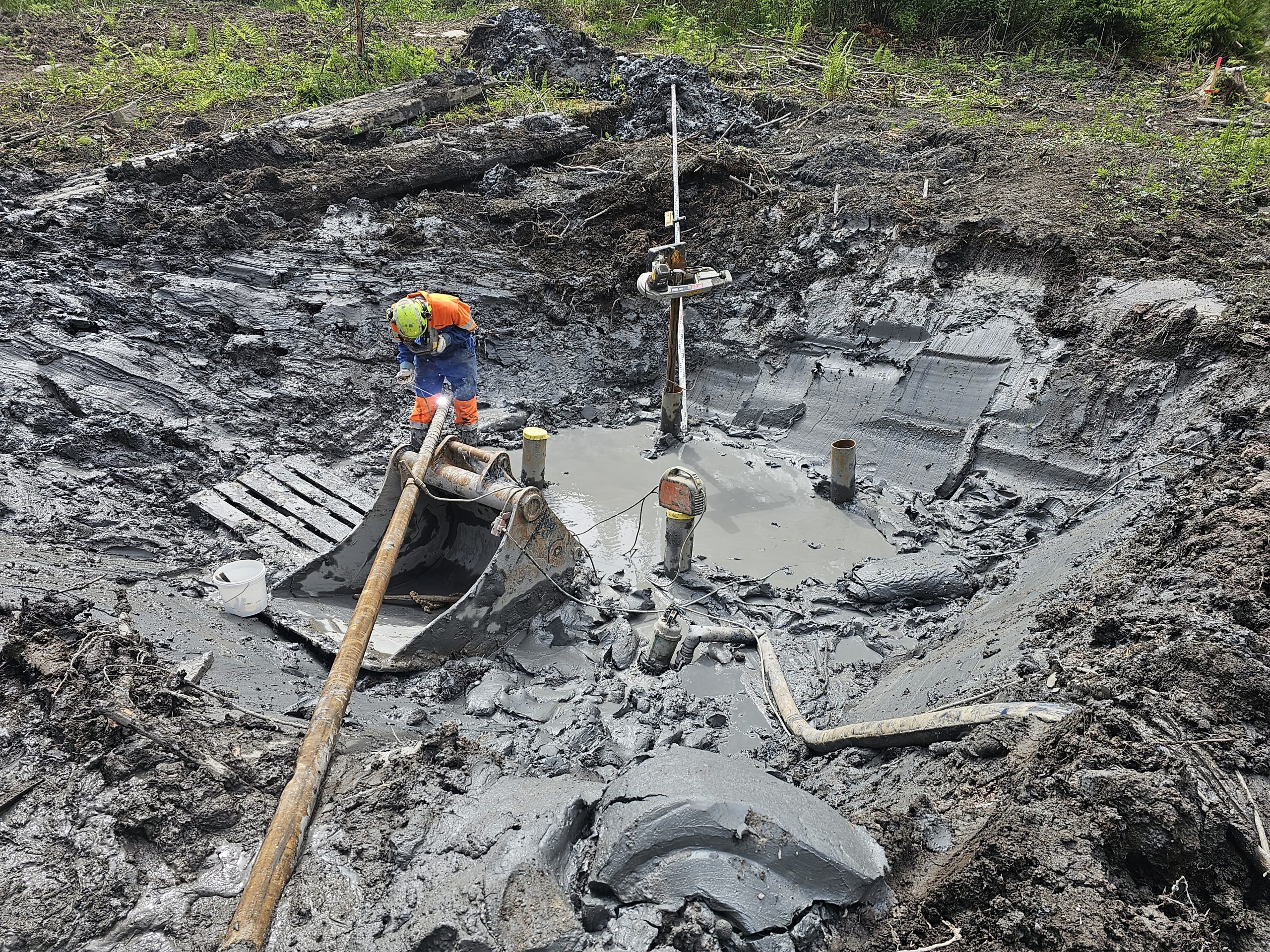
Photo above: Geotechnical fieldwork in Oslo – June 2026. Steel core piling (stålkjernepeling) in soft, brittle clay (sprøbruddmateriale) during foundation works in Oslo, June 2026. The photograph illustrates challenging ground conditions, with exposed soft clay and water accumulation in the excavation. Such projects require careful consideration of bearing capacity, excavation stability, soil disturbance and safe construction methods. This is a practical example of how geotechnics influences both foundation design and construction execution. Photo: Geotekniker AS, Oslo, June 2026.
Engineering geology and geotechnics
Engineering geology and geotechnics are closely related but have different technical emphases.
Engineering geology focuses on geological conditions, rock properties, fractures, weathering and geological structures that may influence engineering projects.
Geotechnics focuses primarily on the mechanical behaviour of soil and ground, including bearing capacity, settlement, deformation and stability.
Many Norwegian construction projects involve both soil deposits and bedrock. Consequently, understanding the relationship between these disciplines can be important when evaluating excavation, foundation conditions or natural hazards.
The difference between geology and geotechnics is particularly relevant when determining which type of professional assessment a project requires.
Geophysical and geotechnical investigations
Geophysical and geotechnical investigations provide information about subsurface conditions before construction or engineering design.
Geophysical methods, including electrical resistivity and seismic surveys, may help identify geological structures, variations in ground conditions and possible bedrock levels.
Geotechnical investigations rely on direct or indirect examination of ground properties through drilling, penetration testing, sampling and groundwater measurements.
A typical investigation programme may include:
- Review of existing geological and geotechnical information.
- Geotechnical drilling and penetration testing.
- Soil sampling and laboratory testing.
- Groundwater and pore pressure measurements.
- Interpretation of soil layers and depth to bedrock.
Geophysical methods can supplement geotechnical investigations but do not necessarily replace direct testing when engineering parameters must be documented.
The scope of a geotechnical site investigation depends on the proposed development, existing information and uncertainty associated with the ground conditions.
Geotechnical laboratory testing and modelling
Geotechnical laboratory testing helps establish the mechanical properties of soil samples collected during ground investigations.
Testing can provide information about water content, density, shear strength, compressibility and sensitivity. The results are interpreted alongside field measurements, geological information and the proposed construction.
For projects involving soft clay, settlement-sensitive structures or uncertain ground stability, geotechnical laboratory testing can be particularly important.
Geotechnical modelling uses engineering calculations or numerical models to evaluate how ground conditions may change during construction and throughout the service life of a structure.
Typical applications include settlement calculations, slope stability assessments and evaluation of excavation-related deformation.
The complexity of the modelling should reflect the actual engineering problem. Detailed numerical analysis is not always necessary, while more demanding projects may require a comprehensive geotechnical analysis.
Where is geotechnics used in construction?
Geotechnics is relevant wherever construction activities interact with the ground.
Foundation engineering involves evaluating soil bearing capacity, settlement and the most appropriate way to transfer structural loads into the ground. The assessment may influence whether shallow foundations, piles or ground improvement measures are suitable.
Excavations and retaining structures require consideration of earth pressure, groundwater, temporary stability and potential effects on neighbouring buildings or infrastructure.
Roads and infrastructure may involve embankments, cuttings, settlement-sensitive deposits and changes in ground loading.
Slope stability assessments evaluate the risk of ground movement or failure in natural slopes and modified terrain.
An understanding of these conditions is essential when selecting suitable foundation solutions and identifying construction-related geotechnical risks.
Geotechnics and ground stability in Norway
Norway has substantial geographical variation in soil and rock conditions. Glacial deposits, marine sediments, bedrock topography and groundwater conditions can create demanding engineering environments.
Below the marine limit, some areas contain marine clay deposits that require particular attention. Certain deposits may contain quick clay or other brittle materials that can lose a substantial proportion of their strength when remoulded.
However, the presence of marine clay does not automatically mean that quick clay is present.
Construction involving excavation, filling or changes in terrain may require an assessment of both local and wider ground stability.
Where quick clay-related landslide hazards are relevant, an assessment of area stability (områdestabilitet) may be necessary. Such assessments consider whether a development could trigger or be affected by a larger landslide.
Erosion, groundwater changes and nearby slopes may also influence the required level of geotechnical investigation.
Eurocode 7 geotechnical design
Eurocode 7 (NS-EN 1997) provides the principal European standards framework for geotechnical design, implemented in Norway with the applicable Norwegian National Annexes.
The framework addresses engineering requirements relating to strength, stability, serviceability and ground investigations.
Eurocode 7 geotechnical design is relevant to foundations, retaining structures, excavations, slopes, embankments and other structures interacting with the ground.
The appropriate design approach depends on the construction, ground conditions and consequences of failure. Further information about the Norwegian regulatory framework is provided in our article on Eurocode 7 and geotechnical standards.
When a project requires dimensioning of specific engineering solutions, geotechnical design and engineering provides the technical basis for construction and documentation.
When is a geotechnical assessment needed?
Not every construction project requires extensive ground investigations or detailed geotechnical calculations.
However, an assessment may be necessary where the proposed development involves uncertain ground conditions, excavation, additional loading, slopes, soft clay or potential natural hazards.
In Norway, municipalities may require documentation that a development satisfies applicable safety requirements before planning permission or a building permit can be granted.
The appropriate level of documentation may range from a focused professional assessment based on existing information to more comprehensive investigations and calculations.
A geotechnical report or assessment documents the relevant ground conditions, engineering considerations and conclusions for the proposed development.
Geotechnical consulting in Norway – Geotekniker AS
Geotekniker AS provides geotechnical assessments, engineering advice and technical documentation for construction and infrastructure projects throughout Norway.
We assist property owners, developers, architects, contractors and public-sector clients with ground-related engineering questions.
Our work includes evaluating existing ground information, identifying stability risks and determining whether additional investigations or engineering design are necessary.
Learn more about our geotechnical services in Norway.
If your project involves uncertain ground conditions, foundations, excavations or ground stability, contact Geotekniker AS for an assessment of the required geotechnical documentation.
Frequently asked questions about geotechnics
What is the difference between geotechnics and geotechnical engineering?
The terms are closely related and frequently used interchangeably. Geotechnics describes the technical discipline, while geotechnical engineering commonly refers to its practical application in design, construction and infrastructure projects.
Is geotechnics the same as soil mechanics?
No. Soil mechanics is a fundamental part of geotechnics, focusing on the mechanical behaviour of soil. Geotechnics is broader and also addresses groundwater conditions, engineering applications and ground-related stability problems.
Are geotechnical investigations always necessary before construction?
Not always. The need depends on existing information, ground conditions, project complexity and applicable requirements. Some projects can be assessed using existing documentation, while others require additional investigations.
Does geotechnics include quick clay assessments?
Yes. Where quick clay or other brittle materials may be present, geotechnical assessments can address local stability, area stability and the potential influence of construction activities.
Can foreign developers obtain geotechnical documentation for projects in Norway?
Yes. Geotechnical consulting services can support foreign developers, engineering companies and property owners undertaking projects in Norway. Documentation must address the applicable Norwegian requirements and the specific project conditions.

Fagansvarlig geotekniker og daglig leder i Geotekniker AS. Han har M.Sc. i faststoffmekanikk (UiO) med videreutdanning i geoteknikk (NTNU, OsloMet) og hydrologi (NMBU). Han har 20 års ingeniørerfaring, blant annet fra Det Norske Veritas, hvorav de siste 12 årene er innen geoteknikk, blant annet som kommunegeotekniker i Lørenskog kommune og i Bane NOR. Geotekniker AS har sentral godkjenning fra DiBK i tiltaksklasse 3.