
Depending on the project, it may include ground investigation results, soil properties, foundation conditions, slope stability, settlement assessments and recommendations for further design.
In Norway, a geotechnical report is commonly referred to as a geoteknisk rapport. The required documentation depends on the proposed development, ground conditions and applicable Norwegian regulations.
Geotekniker AS provides geotechnical assessments and reports for construction projects throughout Norway.
What is a geotechnical report?
A geotechnical report provides information about ground conditions and their significance for a proposed project. Its purpose is to identify geotechnical risks, document relevant assumptions and establish whether additional investigations or engineering assessments are necessary.
Reports are used for residential and commercial buildings, infrastructure, excavations, foundations, retaining structures and land development.
Different projects require different levels of documentation. An initial geotechnical assessment may be sufficient in some cases, while complex projects require extensive investigations and calculations.
For an overview of Norwegian terminology and documentation, see our guide to geotechnical report types.
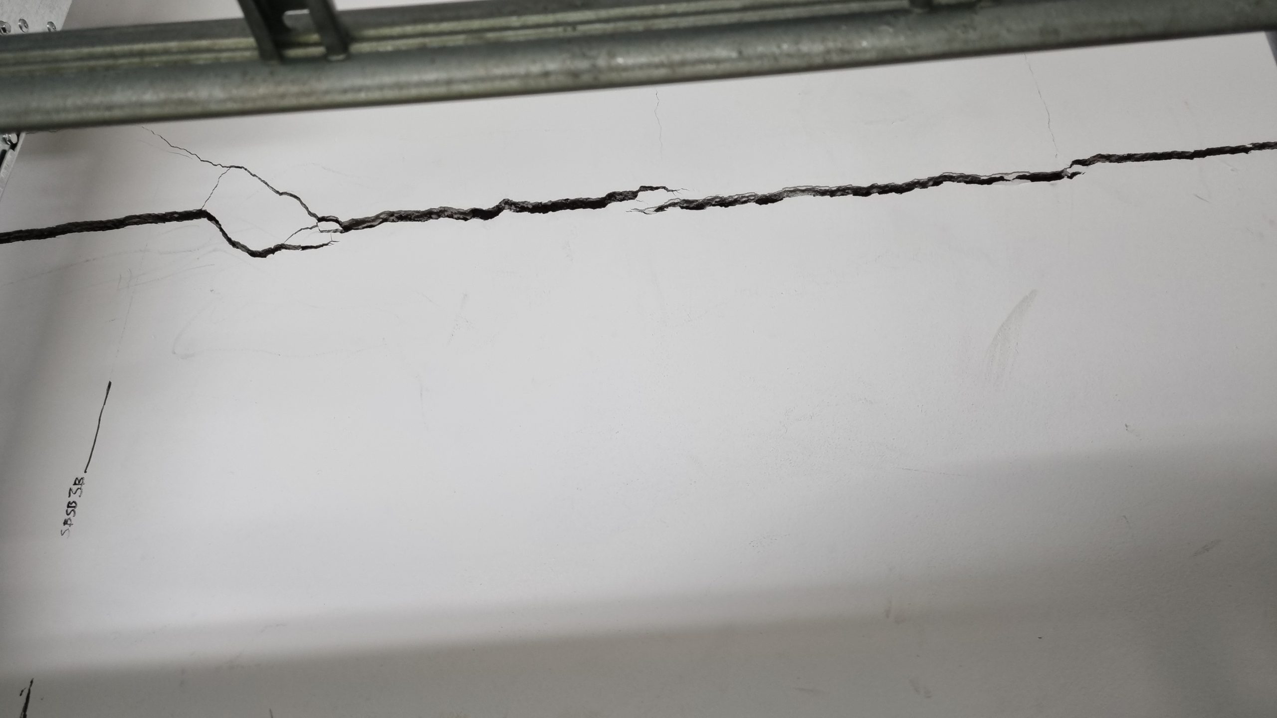
Photo above: Field example – Settlement damage in marine clay, Oslo. This photograph from Oslo shows cracking associated with settlement damage in an area with marine clay. Groundwater lowering was considered a possible contributing factor, as reduced pore water pressure can increase effective stresses and cause consolidation settlements in compressible clay deposits.The example illustrates why a geotechnical report may need to assess groundwater conditions, settlement risks and potential impacts on existing buildings. The precise cause of the damage cannot be established from visible cracking alone. Photo: Geotekniker AS, Oslo, Norway.
What does a geotechnical report include?
The content depends on the purpose and complexity of the project. A typical geotechnical report may address:
- Site location, project description and available ground information.
- Soil stratigraphy, geological conditions and depth to bedrock.
- Ground investigation results and laboratory testing, where available.
- Groundwater conditions and pore water pressure.
- Bearing capacity, settlement and stability considerations.
- Recommendations for foundations, excavations or necessary safety measures.
- Conclusions, limitations and requirements for further investigations or design.
Not every report includes all these elements. The scope must reflect the specific geotechnical issues and documentation requirements.
Types of geotechnical reports
Several English terms are used internationally to describe geotechnical documentation. Their meaning may vary between countries and projects.
Geotechnical site investigation report
A geotechnical site investigation report presents results from field investigations and laboratory testing.
It may include borehole locations, drilling records, penetration testing, soil sampling, laboratory results and groundwater measurements.
In Norway, this type of documentation often corresponds to a geotechnical data report (geoteknisk datarapport).
A data report primarily documents investigation results. Further interpretation and engineering assessments may be required before the information can be used for specific construction decisions.
Geotechnical survey report
A geotechnical survey report is a broader term sometimes used for documentation of subsurface investigations.
The expression may overlap with geotechnical site investigation report. However, it is important to establish whether the document only presents investigation results or also includes engineering interpretations and recommendations.
Geotechnical interpretative report
A geotechnical interpretative report evaluates the significance of available investigation results for the proposed development.
It may assess soil behaviour, stability, bearing capacity, settlements and geotechnical constraints.
In Norwegian projects, this documentation can correspond to a geotechnical assessment report (geoteknisk vurderingsrapport).
The distinction between investigation data and engineering interpretation is important when determining whether the available documentation is sufficient.
Dewatering geotechnical report
A dewatering geotechnical report addresses geotechnical conditions associated with groundwater lowering, pumping or temporary water control.
Such assessments may be relevant for deep excavations, basements and construction below the groundwater table.
Depending on the site, the assessment may address pore pressure changes, excavation stability and the potential for settlement damage to nearby structures.
Read more about groundwater lowering and settlement damage in Norwegian construction projects.
When is a geotechnical report required in Norway?
A geotechnical report may be required for building permits, development planning or construction projects where ground conditions affect safety.
Typical situations include uncertain ground conditions, soft clay, substantial foundation loads, excavations, fills and development on sloping terrain.
Norwegian building regulations, including TEK17 Section 10-2, establish requirements for structural safety. Geotechnical design is normally carried out using relevant Eurocodes, including Eurocode 7 with Norwegian National Annexes.
Projects involving sensitive clay or potential quick clay landslides may also require specific area stability assessments.
Not every building application requires a comprehensive geotechnical report. The required documentation must be determined for the individual project.
Does a geotechnical report require drilling?
Not necessarily.
In some projects, sufficient information is already available from previous investigations, geological maps, terrain analysis and existing reports.
A qualified geotechnical engineer may use this information to establish whether the project can be assessed without additional fieldwork.
Where the available data is insufficient, new ground investigations may be necessary.
The objective is to obtain sufficient and reliable information for the proposed development, rather than undertaking investigations that are not required.
Geotechnical site investigation report PDF and sample
Searches for geotechnical site investigation report PDF or geotechnical site investigation report sample often concern the structure and content of a completed report.
Geotechnical reports are commonly delivered as written PDF documents containing descriptions, assessments, drawings, calculations or technical appendices, depending on their purpose.
A sample report can illustrate how investigation results are presented. However, a report prepared for another site cannot replace a project-specific assessment.
Ground conditions, construction loads and relevant safety requirements vary between projects.
Geotechnical report and geotechnical design
A geotechnical report may provide information and recommendations for further engineering work, but an assessment report does not necessarily constitute complete design documentation.
Foundations, retaining structures, excavations and other geotechnical structures may require additional calculations and verification of specific engineering solutions.
This work forms part of geotechnical design and engineering, where the required technical solutions and design assumptions are established.
How much does a geotechnical report cost?
The cost depends on the required documentation, project complexity and available ground information.
A relatively straightforward assessment based on existing data generally requires less work than a project involving new drilling, laboratory testing and detailed stability calculations.
The most practical starting point is to clarify what the municipality or project actually requires.
For further information, see our guide to geotechnical assessment costs in Norway.
Geotechnical report from Geotekniker AS
Geotekniker AS provides geotechnical assessments, technical reports and engineering services for construction projects throughout Norway.
We assist developers, contractors, engineering consultants and property owners with reviewing existing documentation, identifying geotechnical risks and determining the necessary level of investigation and assessment.
Our services are adapted to Norwegian regulations and the specific requirements of each project. The findings and conclusions are documented in a written technical note or report.
If you need a geotechnical report for a building permit or construction project, see our geotechnical report and assessment services in Norway.
You can also contact Geotekniker AS with the project address, drawings, available ground investigation reports or relevant correspondence from the municipality.
We can help establish what documentation is necessary before the project proceeds.
Frequently Asked Questions (FAQ)
What is a geotechnical report?
A geotechnical report is a technical document that describes ground conditions and evaluates their significance for a construction project. It may include soil investigations, stability assessments, foundation recommendations and geotechnical design requirements.
Is a geotechnical report mandatory in Norway?
Not for every construction project. A geotechnical report may be required when ground conditions affect structural safety, slope stability or foundation design. The necessary documentation depends on the project, site conditions and applicable Norwegian regulations.
What is the difference between a geotechnical report and a site investigation report?
A geotechnical site investigation report primarily documents field investigations and laboratory results. A geotechnical assessment report interprets the available information and evaluates geotechnical risks, design assumptions and possible engineering solutions.
How much does a geotechnical report cost in Norway?
The cost depends on project complexity, available ground information and whether new investigations are required. A straightforward assessment based on existing documentation generally costs less than a comprehensive investigation and design report.
Can a geotechnical report be prepared without drilling?
Yes. Existing ground investigation data and geological information may be sufficient for some projects. However, additional drilling or testing may be necessary when the available information cannot adequately document the relevant ground conditions.
Can I use a geotechnical report sample or PDF for my building application?
A sample geotechnical report can illustrate typical content and structure, but it cannot replace a site-specific assessment. Documentation submitted for a Norwegian building application must address the actual ground conditions and relevant safety requirements.

Fagansvarlig geotekniker og daglig leder i Geotekniker AS. Han har M.Sc. i faststoffmekanikk (UiO) med videreutdanning i geoteknikk (NTNU, OsloMet) og hydrologi (NMBU). Han har 20 års ingeniørerfaring, blant annet fra Det Norske Veritas, hvorav de siste 12 årene er innen geoteknikk, blant annet som kommunegeotekniker i Lørenskog kommune og i Bane NOR. Geotekniker AS har sentral godkjenning fra DiBK i tiltaksklasse 3.