
It helps identify ground-related risks and provides essential information for foundation design, excavations and construction planning.
In Norway, ground conditions can vary significantly, particularly in areas with marine clay, soft soil deposits, steep terrain or variable bedrock depths. A geotechnical survey helps determine whether existing ground information is sufficient or further investigations are necessary.
Geotekniker AS provides professional geotechnical assessments and assists with planning, evaluating and interpreting geotechnical ground investigations for construction projects throughout Norway.
What Is a Geotechnical Survey?
A geotechnical survey examines subsurface conditions to establish a reliable basis for engineering decisions.
The assessment may include soil stratification, depth to bedrock, groundwater conditions, soil strength and potential risks associated with settlement or ground instability.
The terms geotechnical survey, geotechnical investigation and geotechnical site investigation are often used interchangeably. In Norway, the corresponding terms include grunnundersøkelse and geoteknisk undersøkelse.
An investigation does not always begin with drilling. Existing geological information, previous borehole records and site conditions can first be reviewed to determine what additional information is needed.
Read more about ground investigations and their purpose.
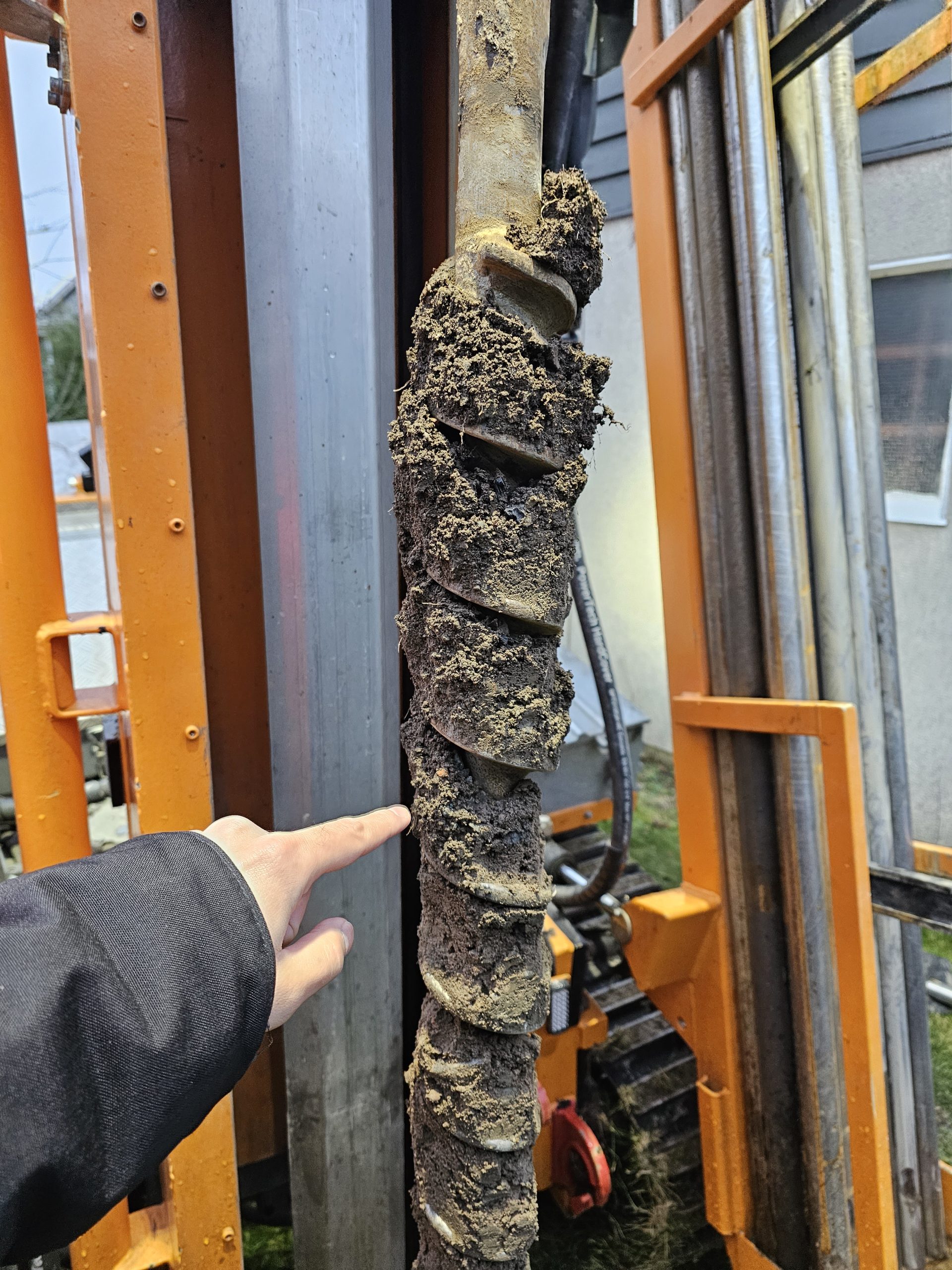
Photo above. The image shows geotechnical drilling from a residential plot in Oslo in 2025, where the auger brought up fill materials likely associated with earlier road construction nearby. This type of field observation is a practical example of how previous site use can affect present ground conditions on a building plot. At Geotekniker AS, experience from projects like this helps us assess whether a site may require additional ground investigation, special foundation considerations or other geotechnical measures before construction.
When Is a Geotechnical Survey Required?
A geotechnical survey may be necessary when ground conditions could influence the safety, feasibility or design of a proposed development.
Typical projects include:
- Residential buildings and housing developments
- Commercial and industrial construction
- Foundations, basements and retaining walls
- Excavations, embankments and terrain modifications
- Road and infrastructure projects
- Development on soft clay or artificial fill
- Construction near slopes or potentially unstable ground
The investigation scope depends on the planned construction, existing documentation and site-specific conditions.
In some projects, available ground information may be sufficient for an initial engineering assessment. In others, additional field investigations are necessary before construction can be designed safely.
Geotechnical Survey Tools and Investigation Methods
The selection of geotechnical survey tools depends on the ground conditions and the engineering information required.
Common investigation methods include total sounding, cone penetration testing (CPTU), soil sampling and groundwater or pore pressure measurements.
These methods help identify soil layers, weak deposits, bedrock depth and properties relevant to the planned development.
Where additional subsurface information is needed, geotechnical drilling provides an important basis for evaluating ground conditions.
Soil samples may also undergo geotechnical testing to determine engineering properties such as water content, shear strength and compressibility. These properties can be established through geotechnical laboratory testing.
The investigation programme should be adapted to the project rather than applying the same methods and investigation density to every site.
Geotechnical Survey Cost in Norway
The geotechnical survey cost depends on the size and complexity of the project, ground conditions, site accessibility and the extent of the required investigations.
A preliminary assessment based on existing documentation generally requires less work than a comprehensive investigation involving drilling, sampling and laboratory testing.
Important cost factors include investigation depth, number of boreholes, equipment access, testing requirements and the scope of the subsequent engineering documentation.
An early review of available ground information can help establish an appropriate investigation programme and avoid unnecessary fieldwork.
For further information, see geotechnical investigation costs in Norway.
Geotechnical Survey Report – Results and Documentation
A geotechnical survey report presents information obtained from ground investigations and provides a basis for further engineering assessments.
Depending on the investigation scope, the documentation may include borehole locations, soil profiles, investigation results, laboratory testing and groundwater observations.
A factual geotechnical data report primarily documents measured and observed ground conditions.
A separate engineering assessment interprets this information in relation to the planned construction, including relevant risks, design considerations and potential requirements for additional investigations.
Geotekniker AS prepares geotechnical reports and assessments for building permits, construction planning and other development projects.
Geotechnical Survey and Ground Risks in Norway
Norwegian construction sites may be affected by marine clay, variable soil deposits, steep slopes and uncertain groundwater conditions.
In areas with marine clay, additional investigations may be required to assess potential quick clay hazards and ground stability.
The investigation results can also provide important information about settlement risks, excavation stability and the suitability of different foundation solutions.
Relevant Norwegian requirements include the Building Technical Regulations (TEK17) and Eurocode 7 (NS-EN 1997), with applicable national provisions.
The necessary documentation must be assessed for each project. A ground investigation alone does not automatically demonstrate compliance with all applicable safety and design requirements.
From Geotechnical Survey to Foundation Design
A geotechnical survey provides information that engineers can use when evaluating suitable foundation and construction solutions.
Depending on the ground conditions, the project may require shallow foundations, piles, ground improvement or additional stability measures.
The findings can form the basis for foundation assessments and subsequent geotechnical design.
Identifying important ground-related uncertainties early can reduce the risk of unforeseen difficulties during construction.
Geotechnical Survey Services in Norway
Geotekniker AS assists property owners, developers, architects and contractors with ground-related assessments and documentation for construction projects throughout Norway.
Our services include reviewing existing ground information, assessing the need for additional investigations and preparing written geotechnical documentation adapted to the planned development.
For an overview of our work, see geotechnical engineering services in Norway.
Planning a construction project?
Send us the property address, available drawings, previous ground investigation reports or relevant correspondence from the municipality. We can review the available information and assess the next steps.
Contact Geotekniker AS for a geotechnical assessment.
Frequently Asked Questions
Does a geotechnical survey always require drilling?
No. Existing ground investigations and geological information may sometimes provide sufficient information. Additional drilling is considered when important uncertainties remain.
How much does a geotechnical survey cost?
The cost varies with ground conditions, investigation methods, site accessibility and documentation requirements. A preliminary assessment can help establish the necessary investigation scope.
Is a geotechnical survey mandatory for building permits in Norway?
Not for every project. The need for geotechnical documentation depends on the proposed development, ground conditions and applicable safety requirements. A municipality may request additional documentation where ground-related risks are relevant.
What is the difference between a geotechnical survey and a geotechnical report?
A geotechnical survey investigates ground conditions. A geotechnical report documents investigation results and, depending on the report type, may include engineering interpretations and recommendations.

Fagansvarlig geotekniker og daglig leder i Geotekniker AS. Han har M.Sc. i faststoffmekanikk (UiO) med videreutdanning i geoteknikk (NTNU, OsloMet) og hydrologi (NMBU). Han har 20 års ingeniørerfaring, blant annet fra Det Norske Veritas, hvorav de siste 12 årene er innen geoteknikk, blant annet som kommunegeotekniker i Lørenskog kommune og i Bane NOR. Geotekniker AS har sentral godkjenning fra DiBK i tiltaksklasse 3.